The 10 Best Photography Spots in Norway’s Lofoten Islands (and where to find them)

How to visit 12 countries in One Year – From Challenge to Reality
16. May 2020
What to do in Slovak Paradise – Ferrata HZS Kyseľ (What to expect)
15. October 2020Have you ever thought about visiting Norway Lofotens? Do you know how to get there? Read on to find out about the best ways to get there by car and ferry from Norway.
Also, are you a photographer, and are you looking for the best spots on Lofoten to take amazing photos? I’ll introduce you to my favourite photography spots on Norway Lofotens, and where you can find them.
Table of Contents
How to get to Norway Lofotens
The best way to get to Lofotens is by ferry. Since there isn’t an airport to get you directly to the Lofotens you have to travel there by sea or by road from the north of Norway. If you are not from the north of Norway or Sweden you’ll likely go from the south of Norway. From either direction you travel from, the best access point to Lofoten is a town called Bødo. From this city is where the ferries run directly to Moskenes and even to the Sørland island.

I recommend you research in advance when the ferries will be heading out (we waited there for two hours). Bødo has a small airport so you can get there by plane, and nearby is a camp with cozy small houses and space to pitch a tent.
You can book seats for all vehicle passengers on THIS PAGE. Please note that the booking fee for a vehicle up to 6 meters is 100 NOK and above 6 meters is 350 NOK. In the summer season – from June to August – it’s better to reserve a place, or else you’ll need to make sure you arrive with plenty of time before the scheduled ferry to fit onboard. Out of season, you’ll have no problem getting on the ferry.
You can check the full schedule on THIS PAGE.
The 10 best photography spots on Norway’s Lofoten Islands
Writing down the 10 best photography spots in Lofotens is a hard task because the Lofoten islands are really magnificent – there are more than 100 places worth visiting! Below I mention how to get to each spot and from where to take the best photos.
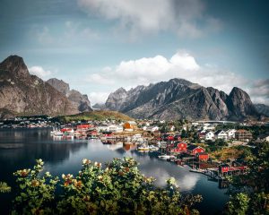
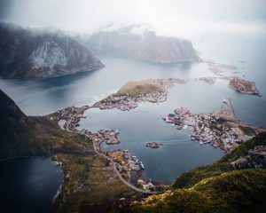
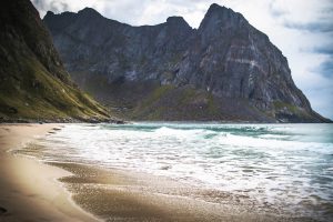
Værøya island
or Værøy is an island in Værøy Municipality in Nordland county, Norway. The island has two villages on it: Nordland (on the northern edge of the island) and Sørland (on the southeastern peninsula). But we are interested in this epic view in the picture below. How to get there and take this shot?
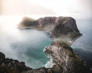
First thing’s first, we need to get to Sørland by ferry from Moskenes. Be aware that the ferries only go once a day! I will show you the scheduling in the table below. You can also get there from Bødo as I mentioned in the first paragraph.
The second step is to get to Håen. This is the place where you can see this epic view of Måstadfjellet. HERE is the parking lot where you’ll park before the hike itself. From there you’ll see the old way up the hill and then you need to follow the blue marked hiking trail which will take you to Håen in up to 40 minutes. All you can do now is take in the beauty and of course, the best photo of the view. It’s definitely worth going for sunset or sunrise as the light conditions are really important here!
| From Moskenes departure to | Monday (duration) | Tuesday | Wednesday | Thursday | Friday | Saturday | Sunday |
|---|---|---|---|---|---|---|---|
| Værøy | 9:45 (75) | 9:45 19:30 |
9:45 | 9:45 19:30 |
9:45 | 10:45 | x |
*Scheduled 7 Jun – 25 August
Scheduling for all seasons
Norway Lofotens Å village
The village (originally a farm) is first mentioned in 1567 (“Aa”). The name is from Old Norse á which means “(small) river”. The name was spelled Aa until 1917 when the Norwegian language reform changed the letter aa to å. The village is sometimes referred to as Å i Lofoten (“i” means “in”) to distinguish it from other places named Å. It is connected to the rest of the Lofotens by the European route E10 highway, which ends here. This part of the highway is also called King Olav’s Road.

What is interesting about this unique place is that the average annual temperature does not fall below freezing. One thing I highly recommend visiting is the Brygga Hotel and Restaurant for the best Norwegian food. You’re spoilt for photo spots here because everywhere you look is another idyllic spot. The small and cozy-looking traditional wooden houses in the village make for amazing photos.
Brygga Hotel and Restaurant
The Munkebu hut hike
is one of the most popular and most beautiful hikes in Norway Lofotens. You will see untouched nature and epic views all the way up. The hut lies 800 meters above sea level and the hiking trail is 5,5 km. The main trail to Munken is located in the village of Sørvågen on Moskenesøy, a few kilometers before the end of the E10 in Å.
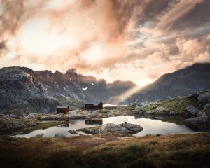
I recommend starting early to catch the best views and it’s definitely worth staying a night at Munkebu. To stay in the Munkebu DNT cabin you will need a key which you’ll find at the tourist information office in Moskenes. Just to note, you will need to become a paying member of DNT to get the key. Or you can stay in your own tent if you have one. Sunrises and sunsets are really epic there and the natural landscape is simply breathtaking.
Full hike description Get the key from Munkebu Hut
Henningsvær soccer field
Henningsvær is a fishing village located on several small islands off the southern coast of the large island of Austvågøya. With the increase in professional and consumer drone photography in the second decade of the 2000s, the Henningsvaer Fotballbanen (soccer field) has gained global attention. The European football organization, UEFA, filmed on and around the field for their “We Play Strong” video with Liv Cooke. Pepsi Max Norge offered their support for the UEFA Champions League Final in 2018 with an art installation created by children kicking soccer balls covered in paint.
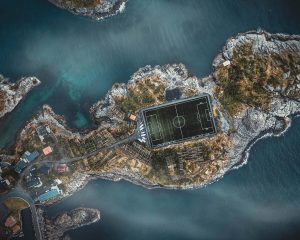
This is a place mainly to take a drone shot and those photographers who have a drone. The way to get there is very simple, just navigate to the soccer field using the navigation on google maps. You’ll need good weather when droning the area and to get the desired shot, the photo needs to be taken at 300 meters above the station.
Norway Lofotens Reine village
It’s no wonder the world media chose this corner of Norway Lofotens as a representative piece. The village still lives from fishing, so fishing sheds are set up along the shoreline, and the traditional Nordic houses are reflected in the beautiful blue water. Some of them are even converted into cozy apartments for tourists. it is the most visited village in Norway Lofotens.
Raine is full of perfect viewpoints of old fisher buildings with striking mountains in the background. This photo spot is located at the beginning of the village a few meters after you turn to Reine from the main road. On the left side is a parking lot from where you walk 20 meters to see this view in full beauty.
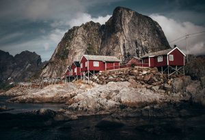
Reinebringen hill
At a modest 448 meters high, Reinebringen is far from one of the highest peaks on the Lofoten Islands. Yet this is more than made up for by the iconic view from the summit. The view, combined with the easy access from Reine and a constant flow of images on social media means that Reinebringen is one of the most popular hikes on Lofoten, with hundreds of people making the ascent each day during the summer season.
The stairway begins on the west side of Ramsviktunnel after following the old road around the outside of the tunnel.
There is no longer much of a trail on Reinebringen, so you just need to follow the steps as they wind their way up the mountain.
After 1560 steps, they currently end at around 400 meters elevation. Leaving you with another 50 meters of ascent on the old trail. Fortunately, this is now above most of the previously dangerous steep areas full of loose rocks. Try to remain on the trail to avoid further erosion.
It’s best to start your hike as early as possible to make the most of the morning lights. It’s also beautiful later before the sun goes down. Views up here are spectacular.
Step by step guide how to get up here
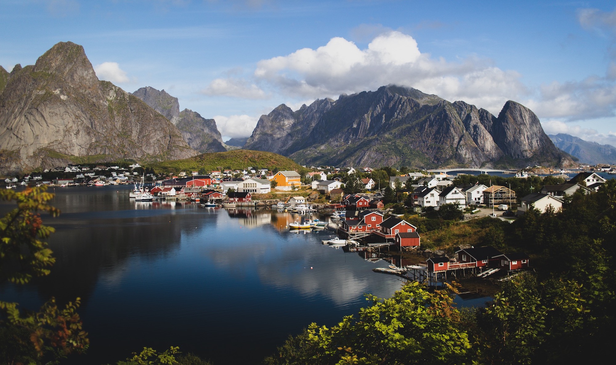
Norway Lofotens Hamnøy village
This is the most iconic village in the Norway Lofotens with its historic red cottages in front of a large rocky mountain. It’s hard to pass over this place and not see the beauty and mood of the area. Hamnøy was previously connected to Reine by ferry, but this was replaced by bridges on the European route E10 highway as part of the Lofoten Mainland Connection and now it’s the only road that connects the rest of the Lofoten from Hamnøy.
The majority of photos of this place are taken from the bridge which ends in Hamnøy. I was a little bit more creative with my angle and this one is taken from under the bridge. After you pass over the bridge turn left at the parking lot, then find a small paved path around the bridge to find the best place below with a view of the village.
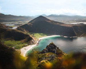
Norway Lofotens Nusfjord village
Fifty years ago, business was booming when codfish came for spawning. Today, Nusfjord is more of a museum than a village, with less than a hundred people living there. Imagine how beautiful this place must have been given that you must pay a fee to even look at the houses. Cruise ships used to pass by this long and now mostly abandoned island world.
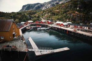
All around the village are hills with higher viewpoints where you can see the entire village like looking at it from the palm of your hand. This one is located in the north of the village above the main port. What is interesting about this village is that you hear the whistling of seagulls all the time which are nested everywhere – even on the old buildings of the village itself. For me is the most beautiful village from all Norway Lofotens villages.
Nusfjord Arctic resort
The ticket to the village costs 100 NOK and you can spend the night there in the beautiful arctic resort.
Kvalvika Beach – Ryten
Located in an isolated bay on the northern side of Moskenesøy and only reached by foot, Kvalvika feels as though it could be at the edge of the world. From here, the turquoise waves crash on the golden sand while vertical cliffs rise into the clouds displaying Lofoten at its very best.
Kvalvika has become one of the most popular hiking and camping destinations on Norway Lofotens. The parking area is far too small to support the crowds, leading to daily traffic chaos all summer long as people illegally park along the (already narrow) road. What once was a quiet peaceful place to camp, you’ll now often find yourself surrounded by 40 or more tents on a warm July night. It’s still a beautiful place, just no longer a quiet one.
How to get there
From any location on Lofoten, take the E10 to Fredvang. After leaving the E10 and crossing the twin bridges, turn left into Fredvang and continue along the road through the village. After approximately 3 kilometers (from the turn) you will see a red boat shed on the left near the water. Immediately past this is a paved parking lot large enough for 10-15 cars. Park here.
Directly across from the parking area you will see a trail heading up the hill. There are several entrance points, but the main one has recently had stone steps added. A new wooden walkway has been built to avoid the previously boggy sections at the start of the trail and there are now several signs pointing you in the right direction at various points.
After 10-15 minutes of hiking, you will be mostly clear of the trees, from there you’ll need to head towards the center of the pass to the north. Elevation gain is gentle here as the path takes you between the two mountains.
Famous Ryten hill hike
Veggen – Uttakleiv Beach – Haukland Beach
Rising nearly 500 meters directly over Uttakleiv beach, Veggen is a big brother to the more popular Mannen. Literally translating into English as ‘the wall,’ what appears at first to be an impossibly steep ascent, is a rather straightforward and well-formed trail – though be warned, the trail does ascend for 400 meters with no relief in steepness, so unfit legs might be burning by the top. With nice views over Uttakleiv and the more distant Haukland and Vik beaches, this is a worthwhile mountain for a midnight hike in summer.
I recommend parking at the parking lot on Haukland beach instead of at Uttakleiv beach as it’s free. From the parking lot, continue along on the right side of the beach under Vaggen itself. You will be going around the hill and you’ll end up at the Uttakleiv beach parking. Looking towards the farm, leave the road and enter the sandy farm track where a single trail will soon appear on the right. This path will lead you up the rocky slope to a small pass between Mannen (on the left) and Veggen (on the right). As you begin to ascend, there are some moderately muddy switchbacks and a few rock steps here and there, but nothing overly difficult.
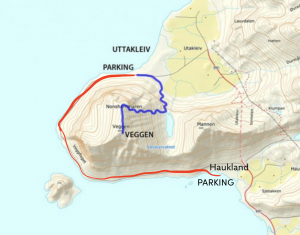
Reaching the top of the pass and the shore of lake Vasskarvatnet, take the worn trail to the right, leading up the right side of Veggen. The ascent is unrelenting but otherwise straightforward as you climb before finally mellowing at around 400 meters as you near the northern end of the mountain.
From here, you have the most amazing views over Uttakleiv. The trail now takes you south along the summit ridge for a gradual ascent, though with a few rock steps, to the summit of Veggen.
The 10 best Norway Lofotens spots on a map
More photos from Norway Subscribe to my travel newsletter More information about me